It’s an exciting time for transit in Toronto. After decades of slow investment in transit infrastructure, the Toronto region at last has a suite of major rapid transit projects and upgrades underway or under study.
Last Tuesday, staff at the City of Toronto and Metrolinx released updated recommendations for the various transit projects that will be considered by the City of Toronto Executive Committee and the Metrolinx Board, respectively, at their June 28 meetings. The decisions that will be made tomorrow are big, as they will unlock detailed costing, environmental assessment and funding negotiation processes.
We’ve seen Toronto transit plans come and go in recent years, and when you add the province-level plans into the mix, it can be hard to keep them straight – even for the most dedicated observer.
In addition to three rapid transit projects that are underway (Toronto-York Spadina Subway Extension, Eglinton Crosstown LRT, Finch West LRT) and one that’s been funded but postponed (Sheppard East LRT), at least six other projects are currently being studied:
- SmartTrack / GO RER integration (the latter led by Metrolinx)
- Eglinton Crosstown LRT West Extension (bundled with SmartTrack)
- Downtown Relief Line
- Scarborough Subway Extension
- Eglinton Crosstown LRT East Extension (bundled with Scarborough Transit Planning)
- Waterfront “Reset” (at a more preliminary stage)
Built out, here’s what this would look like:
Map 1: Proposed, underway and existing rapid transit projects *
We urgently need these projects to get closer to the transit system Torontonians want. However, new transit comes with a big price tag, and our ability to bankroll multiple projects at once may well prove to be limited.
We need to prioritize transit projects that get the most people out of cars. There are many ways this can happen – by better connecting people to jobs, ensuring suburban density and urban intensification and planning future development around transit. Many of these criteria are outlined in The City of Toronto’s Rapid Transit Evaluation Framework. We dug deep into one of these criteria – building transit that connects people with jobs.
Connecting to employment
With 1.4 million jobs in 2015, Toronto is a key driver of the provincial and national economies. Over half a million of these jobs are located downtown. One of the reasons our existing lines need “relief” is that so many people are headed to the downtown centre.We need to ensure that all employment hubs will be connected to transit so they can draw riders to less trafficked parts of the system.
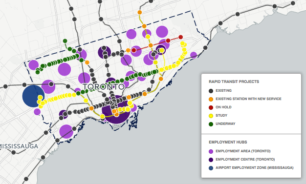
In addition to the downtown, the City of Toronto recognizes four employment centres and 22 employment areas, as illustrated on the map below.
Here’s how the proposed and underway projects can connect people to jobs.
Map 2: Proposed, underway and existing rapid transit projects with Toronto employment areas and centres **
- In the east, SmartTrack would add a connection to the South of Eastern employment area (where planned intensification at the Unilever site will add many additional jobs) and the West Central Scarborough and Milliken employment areas. In the west, SmartTrack would add a connection to the Liberty employment area (a major hub of recent growth) and the Weston Rd./Mt. Dennis employment area.
- The Eglinton Crosstown LRT West Extension would connect the Airport employment area and the Weston Rd./Mt. Dennis employment area.
- The Downtown Relief Line would provide an alternate route to the Downtown Centre and also connects the South of Eastern employment area.
- The Scarborough Subway Extension would connect to the Scarborough Centre.
From a high-level planning perspective, locating rapid transit near employment hubs is a great start. However, most of the employment hubs are too large to walk across, and proposed stations tend to be located on the edge only. Truly serving these areas will likely involve planning effective local transit and building bike lanes to the rapid transit stations to ensure that workers and shoppers can quickly get to where they need to go.
Moving forward, it’s important that we evaluate these projects as part of a connected network. Employment in the City of Toronto has grown by 12.7% in the last decade, and the population is continuing to grow dramatically. We want to see plans that prioritize transit that connects the most people to where they need to go, and that makes commuting by transit a real option for Torontonians. We’re excited to see the outcome of tomorrow’s executive council meeting and we’ll be watching closely to see how the transit plans progress.
* Map 1 notes:
- Waterfront Reset not shown as corridor not yet determined.
- Station locations and alignments for proposed transit are not precise. They are based on currently available public information and are presented for general analysis purposes only. Please consult the project websites for more detailed location information.
** Map 2 notes:
- Job numbers are from the Toronto Employment Survey 2015. Employment centres and areas have been represented as points approximating their geographical centre, but they are in fact areas of varying shapes and sizes. Whether or not the employment hubs touch the transit lines on the map should not be interpreted as a presence or not of a direct connection between the employment hub and the transit line. For more details on their locations, see the Toronto Employment Survey 2015 Bulletin.
- Educational and health institutions are not shown but are also important destinations to serve with transit.
- The Airport Employment Zone, though not within the City of Toronto, has been added due to its importance as an employment hub in the region.


